A Place-Name Walk Through Bournemouth’s Changing Map
A Bournemouth place-name walk helps you compare signs and maps, notice naming patterns and keep visible clues separate from claims about local history.
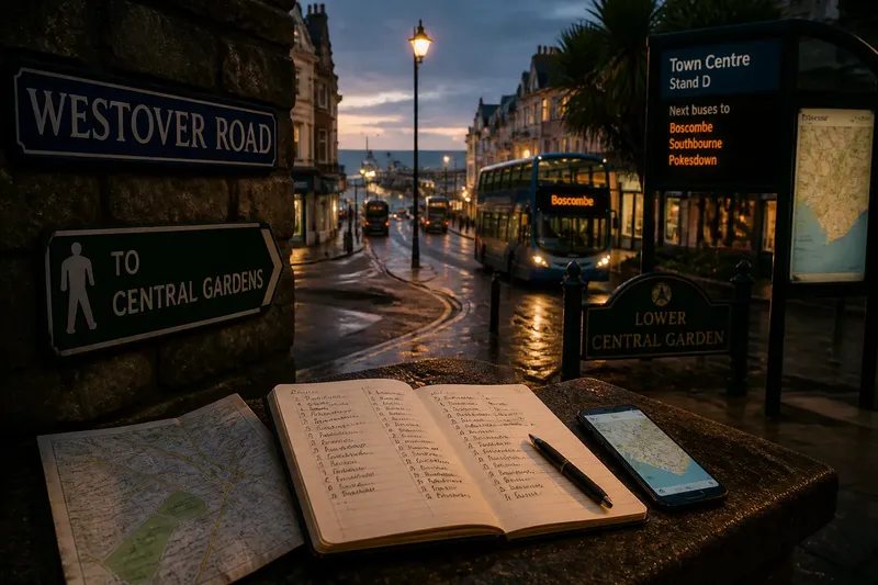
At a Bournemouth street corner, a blue road sign may use one name while a nearby bus stop, green space or map label uses another. A Bournemouth place-name walk turns that small mismatch into a way of reading the town: notice what names are used, where they recur and what the evidence can—and cannot—tell you.
The point is not to solve every name’s origin on the pavement. It is to look carefully at the layers of naming around you, then distinguish an observable pattern from a tempting story. A name can suggest a connection, but by itself it does not prove when a place was named or why.
Start with names you can actually see
Choose a compact route through familiar streets, perhaps linking a high street, a public garden and a road towards the seafront. Keep the walk easy to follow; the exercise is about attention, not distance. A paper map or an offline map on your phone can help you compare what is printed with what is on the ground.
At each junction or public space, note names from different sources: street plates, directional signs, bus-stop displays, park entrances and map labels. Record the wording exactly, including any abbreviations. If a sign gives only a partial name, do not silently fill in the rest from memory.
A pocket notebook is useful, but a simple note on your phone will do. Make three columns: name, where it appears and what I can observe. Keep the last column factual. “Appears on a street plate and the map” is an observation; “named after a local benefactor” is a historical claim that needs separate evidence.
Compare naming patterns rather than guessing origins
As you walk, look for repeated forms. Several nearby labels might include words associated with roads, gardens, buildings or landscape features. A name may also recur across a street, a stop and a public place. These repetitions can help you see how a label travels through the town’s wayfinding, even if they do not explain where it began.
Compare the kinds of names, too. Some may describe a feature, others may use a personal or family name, and some may be distinctive labels with no obvious meaning from the sign alone. Treat those as categories for observation, not proof of a particular naming history. A familiar word can have more than one origin, and local usage can change over time.
Notice spelling and form without assuming that every difference is significant. A shortened label on a transport display may simply fit the available space. A map may use a formal name where residents use a shorter one. The useful question is not “Which version is the true one?” but “Who uses this form, and in what setting?”
Use maps as a second layer of evidence
Maps gather names into a system, while street signs place them in daily view. Compare the two without expecting them to match perfectly. A map may include a broader area label that is absent from nearby signs, or a sign may identify a particular entrance rather than the whole green space.
Scale matters. On a small-screen map, minor labels can disappear or shift as you zoom; on a printed map, crowded wording may be abbreviated. Look at a larger-scale view when a name seems misplaced, and check the map legend if it uses symbols or short forms. Different maps can also serve different purposes, so their choice of labels need not be identical.
Say you notice “The Square” on a map and a nearby sign pointing towards a differently worded destination. You could note both labels, mark where each appears and check whether the map is naming a broader area while the sign identifies a specific place. The expected result is a clearer record of how the names function, not a newly proven account of their origin.
Keep the walk curious without making it a research project
For a useful record, collect a small set of observations rather than trying to transcribe every sign. For each stop, note:
- The exact name and its spelling.
- The type of source, such as a road plate, map or park sign.
- Whether the same wording appears elsewhere on the route.
- Any visible feature the name seems to describe.
- One open question that would need another source to answer.
Afterwards, sort the notes into “observed” and “to check”. If you want to investigate an origin, look for a reliable local history source, an official place-name record or archival material that directly addresses the name. A source that merely repeats a popular explanation is not the same as evidence for it.
What is not worth the effort is treating every syllable as a hidden clue or searching for a grand story behind every street. That approach can turn a pleasant walk into guesswork. A modest question—where does this name appear, and what does it seem to label?—often produces a more accurate picture.
What can a place name tell you?
Does a name prove how a place began?
No. A name is a clue to investigate, not proof of its own history. Establishing an origin requires evidence that connects the wording to a particular person, feature or event.
Why might a map and a sign use different names?
They may refer to different things, such as a larger area and a specific entrance, or use a formal and shortened form. Compare where each label appears before treating the difference as a contradiction.
Should local pronunciation go in the notes?
Yes, if you hear it in ordinary local use and can record it accurately. Keep spoken usage separate from official spelling, and avoid presenting one person’s pronunciation as universal.
Where can I check a name’s history?
Consult sources that address the place directly, such as local archives, published histories or official naming records. Check what the source actually supports rather than relying on a name’s apparent meaning.
Let patterns guide the next question
When the route is over, read the notes as a small map of naming in use. A cluster of repeated labels may show how signs and maps organise a neighbourhood; a mismatch may reveal that different sources are describing different places. Neither observation settles an origin, but both help you ask a sharper question.
That is the lasting value of a Bournemouth place-name walk: it makes ordinary signs legible without asking them to carry more history than they can. Keep the wording, location and source together, and the next time a name catches your eye, you will know what to notice—and what still needs checking.